
Rail-trail could reduce dependency on cars
By Nick Tabor, New Era Senior Staff Writer
Some
winter days, Jane Hall, 83, puts on long johns and a sweater and two coats
before going out. Ignoring the wind, she walks to the grocery store, Dollar
General, her bank or her doctor’s office.
Hall
walks everywhere. Her habits were forged in the 1930s and ‘40s, in rural parts
of the county, when the roads were dirt and mule-driven wagons were common.
Hopkinsville has sped up
around her. Now most streets are paved, have high speed limits and are mainly
for automobiles. She admits her routes are unsafe, as they lack sidewalks, but
she never learned to drive.
“People
just too lazy to walk,” she said in her living room. “They’d drive their cars
to the mailbox if they could.”
But
like most people, she takes infrastructure for granted.
City
officials recognize many parts of Hopkinsville
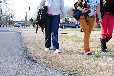
encourage driving over walking. As in many U.S. cities, especially rural ones,
civil engineering — speed limits, road width, signage — often treats walking as
an afterthought at best.
The
city rates 34 out of 100 on Walk Score, an Internet service that makes
calculations from geographic data. Some parts of town rate higher or lower, but
the total score gives it the designation “car-dependent.”
Certain
public health studies suggest a city’s friendliness toward walkers and
bicyclists — not just for exercise, but for transportation — is no less
important than access to healthy food and recreational facilities. It shapes
people’s habits.
Seeing
this need, the Christian County Health Department may contribute money to the
rail-trail conversion.
In
public forums, most conversation surrounding the trail has focused on its
potential for exercising. But the designers also intend it as a means of
transportation, a path for reaching destinations.
The
trail would make Hopkinsville
more walkable.
Safety,
access, aesthetics
Peter
Lagerwey, a transportation engineer who was once bicycle-walking coordinator
for the city of Seattle,
says three basic factors determine walkability: safety, accessibility and
aesthetics.
All
three are hard to quantify, but a few numbers do help.
Sidewalks
help with safety by getting walkers away from traffic. The city has 65 miles
worth of sidewalks, said Terry Rudd, superintendent of the Hopkinsville Street
Division, in an interview last year.
A
number of neighborhoods developed in the 1960s and ’70s — such as Deepwood,
Hunting Creek, Givens Addition, Indian Hills, Holiday Park
and the Springmont area — have no sidewalks. But in the last few years, as part
of the Residential Enterprise Zone program, the city has required developers to
include sidewalks in new neighborhoods to qualify for incentives.
Steve
Bourne, director of Community and Development Services, mentioned several new
subdivisions that have benefited from this policy — Daven Drive (west of the Hopkinsville
Country Club and LaFayette Road),
Sivley Trace, and the Villas, across from the YMCA.
Last
year the city had 12 accidents involving vehicles and pedestrians, including
one fatal accident and seven others with injuries, said Officer Paul Ray,
spokesman for the Hopkinsville Police Department.
By
accessibility, Lagerwey means being able to reach destinations by walking. If a
neighborhood has a safe, quiet street that loops around in a circle, it’s fine
for exercise but doesn’t really improve walkability.
“You
need to be able to get where you want to go,” Lagerwey said.
Downtown
Hopkinsville
has its restaurants, its bars, a coffee shop, a book store, furniture shops and
some other businesses. But only one grocery store — Piggly Wiggly — is nearby.
Downtown has no movie theater, no laundromat and limited choices for buying
clothes.
Even
if they lived in the city’s center, hardly anyone could get by in Hopkinsville for more
than a week or two without depending on a car or taking their chances on busy
streets.
The
city has made recent strides to make downtown more attractive. For instance, it
put a foot bridge over Little River behind the West
Seventh Street
Park and cleared trees in front of the
Christian County Courthouse to give a clear,
attractive view from Sixth Street.
New signs will go up soon in green and red tones that match the signs chosen
for the rail-trail.
But
ultimately, everyone has to judge Hopkinsville’s
aesthetic qualities for themselves.
Spacial
relationships
The
railroad bed destined for the rail-trail runs north and south through Hopkinsville. For the
first phase, 3 miles long, the city would put a trailhead at Pardue Lane, then
pave the area that runs north beyond Cox Mill Road and Canton Street, to North
Drive.
There
it makes a T, with one side extending west to the North Drive park and the other going east
to Westside Park, connecting with the river trail
bordering downtown on the west.
Given
all the neighborhoods that surround it southwest of downtown, hundreds of
residents could walk there from home.
From
the trail’s south end, walkers could easily reach North Drive restaurants like Da Vinci
Little Italian and Pizz-A-Roma — without crossing busy streets.
On
the other hand, for most people who live close enough to downtown to walk
there, the trail won’t provide a more efficient route. Nor does it connect to
the dense business districts on Fort
Campbell Boulevard and West Seventh Street.
Later
extensions, which will pave the trail all the way down to the Eagle Way bypass,
might help people reach downtown without cars.
Lose
& Associates, the Nashville firm that
designed the trail, has done similar projects all over the southeastern U.S. In Nashville and Murfreesboro,
Tenn., where the trails lead into
downtown from the suburbs, people love relying on them instead of driving.
“They
get tons of use for that,” he said.
Lagerwey
said the key is to integrate rail-trails with safe, walkable roads.
“They’re
always part of a network,” he said. “You’re never going to have a rail-trail to
everybody’s front door and everybody’s place of business.”
Often
city dwellers can reach their local trails by walking a mile or less.
On
Lagerwey’s other criteria, safety and aesthetics, Hopkinsville’s rail-trail could score high.
It would prohibit motor vehicles, and most of it lies in the woods.
Public
health
Two
Yale researchers published a study in December, showing people who used “active
transportation” — such as walking or bicycling — tended to have lower body mass
indexes and lower odds of hypertension.
They
found that people who engaged in more than 150 minutes of active transportation
each week were 30 percent less likely to have high blood pressure and diabetes.
They
called active transportation “an untapped reservoir of opportunity for physical
activity for many adults.”
By
examining data from the National Health and Nutrition Examination Survey, they
discovered less than a quarter of U.S. adults surveyed used active
transportation continuously for 10 minutes in a typical week.
In
a meeting last week of the Christian County Board of Health, officials talked about a
study in which the healthiness of Christian
County’s environment
ranked 116th out of the state’s 120 counties.
But
the study accounts for many factors, including the prevalence of fast food and
availability of healthy food. It does a poor job of accounting for recreation
facilities; for instance, it doesn’t count YMCAs.
The
Yale study suggests it was perceptive to consider walkability.
The
board of health did not set a precise timeline for deciding whether to
contribute money. Meanwhile, the city is beginning to seek funds from local
businesses. Mayor Dan Kemp hopes the city council will vote this spring to pay
for the remainder with city funds.
In
the best-case scenario, construction could start in the late spring and end
around November, Kemp said.
No comments:
Post a Comment